Into the Sunset

IMG_0645Today heralds the winter solstice in the northern hemisphere. The last couple of weeks leading up to this seasonal turning point have been characterised, in eastern England at least, by unseasonally sunny skies and sunsets so magnificent they seem to be defying the script that dictates that late December should be grim, grey and gloomy. These are short days, certainly, but days that have been beautifully illuminated by a cool, low-slung orange sun. Oddly enough, this has put me in mind of another orange sun in an altogether more exotic place.

IMG_0648

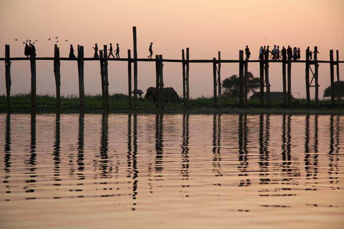
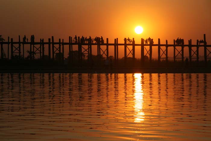
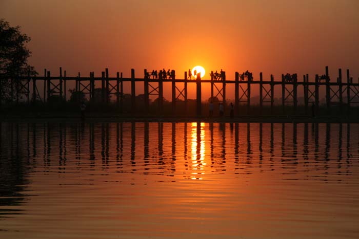
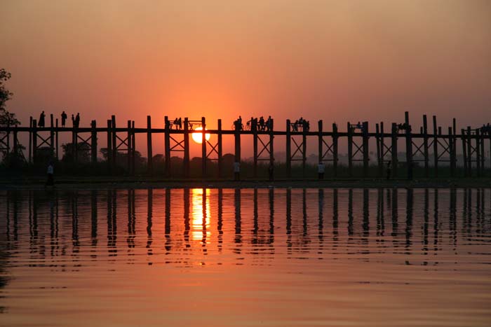
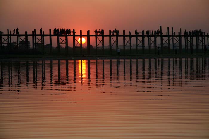
U Bein’s Bridge at Amarapura near Mandalay in Myanmar/Burma is a well-known tourist hotspot in that country. The 1300m-long footbridge is thought to be the longest teak bridge in the world but that is not really the reason why visitors flock here. The truth is: this particular bridge is so photogenic that if you have ever perused the glossy travel literature offered by tour operators that deal with Myanmar the chances are you will have already seen it. Tour companies tend to know what tourists want and U Bein’s Bridge is a prime example of how the iconic and visually appealing has been successfully commodified. If aesthethic capital were on par with economic capital then Myanmar would be a wealthy country.

IMG_0650

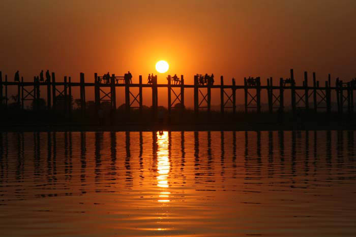
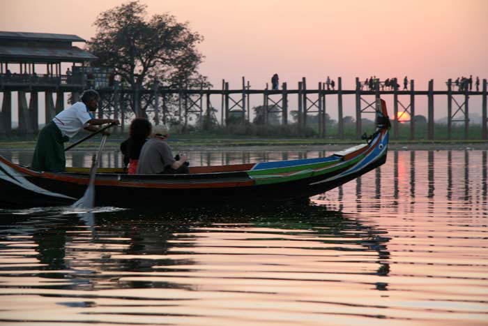
Tour leaders tend to make sure that their foreign clients arrive here just before sunset – just enough time for a short boat excursion on Lake Taungthaman to get the best shots. While the sight of the bridge silhouetted by the setting sun is undeniably lovely, the experience can seem somewhat surreal as hordes of freshly arrived westerners eagerly snap the scene from gently bobbing boats rowed by local fishermen. The  impoverished fishermen, who have never owned even the most rudimentary camera in their lives, are sufficiently familiar with the ritual to know exactly what to do and where to go. Meanwhile, the monks and villagers who obligingly cross the bridge and unwittingly silhouette themselves for the benefit of the foreign photographers seem oblivious of their walk-on role in this unfolding daily drama.

IMG_0655

IMG_0663

IMG_0668

IMG_0672

Yugostalgic Belgrade

IMG_1948Although Tito was half Croat and half Slovene he spent most of his time as Yugoslav helmsman in the Serbian capital, Belgrade. It is here, in the leafy Topčider suburb that lies south of the city centre, where you can find the former leader’s memorial complex – an art gallery, museum and mausoleum scattered among birches, landscaped lawns and whimsical statuary. When I first visited back in 2005 this was a fairly neglected place. I don’t remember there being any other visitors and once the guards had let me through I had the place to myself. What I remember as being poignant were the one-way arrows on the walkway that led up to the mausoleum – indicators of once-necessary pedestrian traffic control that had long become meaningless.

IMG_1905         IMG_1939

Fast-forward seven years to a return visit. This time it is certainly busier and now there are English-language signs and even a gift shop at the gatehouse. Although the House of Flowers does not see the crowds that would have assembled here in the 1980s there appears to be a slow renaissance and I am informed that even a group of Slovene Hells Angels now make an annual pilgrimage here on 25 May, Tito’s birthday.

Ever the unrepentant tourist, I purchase a Tito mug and mouse-mat but pass on buying a T-shirt. At the mausoleum itself – the poetically named ‘House of Flowers’ – I swap cameras with a Romanian visitor as we take turns to pose by the marble slab that bear the simple inscription: Josip Broz Tito 1992 –1980. The ‘Old Museum’ next door bears a collection of the gifts presented to Tito during his long presidency. The gifts – no doubt just small sample – range from homemade socks and hand-stitched blouses to weaponry and musical instruments. Tito apparently loved dressing up and, correspondingly, there are plenty of costumes on display too, the most remarkable of which is a Bolivian witchdoctor’s outfit. Tito always was something of a shaman.

IMG_1913     IMG_1924

There are still those that miss him. Tito ruled for 35 years until his death in 1980 but his memory has been laced with ambiguity since the traumatic breakup of the Yugoslav federation. In recent years, though, there has been a considerable amount of revisionism taking place in the Balkan region. So-called ‘Yugostalgia’ is one reflection of this. Playful and ironic, as well as sentimental and nostalgic, the commonest expression of this phenomenon seems to be the Yugostalgia theme-café. There’s an excellent one in Sarajevo right next to the war museum but others can be found throughout the former Yugoslavia(although probably not in Kosovo where Bill Clinton is still undisputed king).

IMG_2129     IMG_2130

On my last trip to Serbia, the Republika café in Belgrade’s Skadarlija quarter, a former bastion of Yugostalgia, seemed to have closed for business but I was more than compensated in discovering a new kafana (traditional café-restaurant) behind the Vuk Theatre in the city centre. Like all the best places in Belgrade, Kafana Pavle is a little hard to find. Tucked away down a graffiti-scrawled alleyway that seems to go nowhere, its presence is given away by a menu card in a steamed-up window that proudly displays the red star and hammer and sickle. Inside, it’s an Aladdin’s cave of Yugostalgic bric-a-brac – framed photos of Tito, Lenin and even Stalin (if Stalin on display then you can be sure the intention is tongue-in-cheek). Shelves are piled with dog-eared photo books of old Yugoslavia and stacks of 1970s Yugo-rock LPs that have hairy young men sporting flared trousers and mullets on the cover. On the wall hangs a map of the former Yugoslavia in the shape of a red star.

IMG_1959    IMG_1918

Of course, all this serves as homage to a country that no longer exists but at least you can get a taste of what it might have once been at rare enclaves such as this. Just be sure to bring along a sense of irony and check in your cynicism at the door.

Walking in Norfolk

51Ym0tIQenL__SY445_

My new Cicerone walking guide, Walking in Norfolk is going to be published in a week or two’s time and so here is a small taster of what to expect. The book contains 40 circular walks in all, and covers all parts of the county from northeast Norfolk to the Waveney Valley to the Fens.

Here’s a bit from the Introduction:

‘Very flat, Norfolk’, asserts Amanda in Noël Coward’s Private Lives, reflecting pretty much the commonly held view of the county: a place, with attitude perhaps (think of its heroes – Horatio Nelson, Thomas Paine, Delia Smith, Stephen Fry…Alan Partridge), but certainly not with altitude. The stereotyped view, although misleading, is understandable enough, as most people have some sort of image of Norfolk even if they have never visited the county. Many will have seen the vast sandy expanse of North Norfolk’s Holkham Beach in films like Shakespeare in Love or TV programmes like Stephen Fry’s Kingdom. Many more will think of boating holidays on the Norfolk Broads, or make associations with the low-lying Fenland region of the far west of the county: aspects of Norfolk, certainly, but not the full picture by any means.

…and here’s a snippet from Walk 10: Burgh St Peter and ‘The Triangle’:

039‘The Triangle’ is a local name that was sometimes used to refer to the parishes of Aldeby, Wheatacre and Burgh St Peter in southeast Norfolk. Bound on two sides by a bend of the River Waveney and on the other by the now-dismantled Beccles to Great Yarmouth railway, the triangle of land so defined has something of the feel of an island to it. There is no through road here, just a quiet single-track lane that links the farmsteads on the marshland edge. To the north, east and south a large flat area of marshes lies between the relatively high land of ‘The Triangle’ and the river itself.

041Burgh St Peter’s Church of St Mary the Virgin is one of Norfolk’s oddest churches as its tower is in the form of a five-section ziggurat (or, as some have fancied, a collapsible square telescope). The body of the church dates from the 13th century but the tower is an 18th-century addition, supposedly inspired by the Italian travels of William Boycott, the rector’s son. A dynasty of Boycotts served the church for a continuous period of 135 years and Charles Cunningham Boycott, the son of the second Boycott rector, gave the term ‘boycott’ to the English language when he behaved badly over absentee rents in Ireland and was socially ostracised as a result.

Einstein on the Heath

It’s been a long time since my last post. The main reason for this is that I have been busy working on Slow Norfolk, a new guide for Bradt that is scheduled for publication early next year. Rather than a new edition of Slow Norfolk & Suffolk, that guide will become two separate books in the future: Slow Norfolk and Slow Suffolk. Naturally, there will be a degree of cut and paste involved but, as well as a fresh look and a new emphasis – less in the way of listings, more in the way of a personal take on the county — there will be lots of new material that celebrates that which is strange, quirky and particular about the county. For a taster of the sort of thing that Slow Norfolk will contain, here’s a snippet about a certain German physicist’s brief sojourn in north Norfolk.

Einstein on the Heath

U237135ACME[1]

A couple of miles southeast of Felbrigg Hall is the village of Roughton on the Norwich to Cromer road. Although the village is unremarkable, Roughton Heath just to the north was the unlikely residence of Albert Einstein for a few weeks in 1933. The celebrated German physicist was brought here under tight security to live in a small hut on the heath after fleeing Nazi Germany. Whilst living in his modest hut Einstein continued with important work that would later be put to use developing the world’s first atomic bomb. The scientist also found time to pose for a sculpture by Jacob Epstein. It was this brief episode by the Norfolk coast that provided inspiration for Philip Glass’s opera Einstein on the Beach. A blue plaque commemorating Einstein’s short-lived residence on the heath adorns the wall of the New Inn in Roughton village. The whereabouts of the hut itself is not known.

Serbia 4

1849[1]

The new edition of my Serbia guide is published today. It’s fully updated, of course, with revised text and lots of new listings, especially for Belgrade, a city that despite considerable setbacks seems to drive itself forever onwards and upwards. Here’s a snippet from the new edition that describes a possible future development for the Serbian capital. It looks quite remarkable (although probably hugely expensive too).

A ZAHA HADID DEVELOPMENT FOR KALEMEGDAN?

A large plot of land between Kalemegdan Fortress and the Dorćol riverfront is currently awaiting development. Originally owned by Beko, a company that went bankrupt, the land has been bought by Lamda development, a Greek company that is part of a holding company with EFG Bank and EKI Petrol. The Greek company approached the studio of Zaha Hadid to come up with a project for the land and the Iraqi-British architect has come up with a stunning plan for the development: a sweeping modernist design that connects with the surrounding landscape and incorporates essential public spaces and public transition between the fortress and the riverfront. At the time of writing, the proposed project was still awaiting public review (www.beobuild.rs). The design can be seen on line at: http://www.zaha-hadid.com/architecture/beko-masterplan.

Belgrade’s not a stranger to developments that never quite get off the ground. Here’s another snippet from the Belgrade chapter of Serbia 4:

GOING UNDERGROUND – THE METRO THAT NEVER WAS

At the edge of Ćirila i Metodija Park in the city centre, under the whiskery gaze of Vuk Karadžić whose statue graces the western corner, are several entrances that lead down to what appears to be an underpass. But there is more to this than you might imagine: this is the location for the only station on Belgrade’s metro. The station, known simply as Vukov Spomenik (‘Vuk’s Statue’) was to be part of an underground system that never came to fruition, and which, as things turned out, ended up being one of the city’s biggest white elephants. It was built during the Milošević period in 1995 as the first component of what would be a comprehensive underground network but the turn of events in Serbia in the late 1990s resulted in the country having far more pressing needs than that of a highly expensive underground railway. The part that was completed is well worth seeing, even if it is a bit surreal. A number of entrances lead down to a stylish atrium in brushed steel from where escalators plummet down further to the platform. The station has since found use as a stop on the Beovoz line that plies between Zemun and Pančevo and a few shops have opened for business in the atrium.

IMG_2152

IMG_2153

Fiesta

 IMG_1467Small town Spain at the end of Whitsun. In Alhama de Granada, a hill town midway between Malaga and Granada in Andalucía, the celebration of Corpus Christi on the first Sunday in June takes the form of a religious procession through the streets of the old Arab town. The event is announced by a stirring peal of bells from the huge earthquake-scarred tower of the Church of La Encarnación. Temporary flower-decked altars have already been set up strategic points along the processional route, the course of which is marked by a wide swathe of horsetail gathered from the nearby gorge.

IMG_1531Musicians carrying trombones and drums saunter across Plaza de la Constitución to assemble outside the main door of the Iglesia del Carmen that overlooks the gorge. Eventually, the congregation files out of church and after a fanfare of deafening fircrackers the procession leaves to make its way around the town’s narrow streets. Leading the entourage along with the priest are girls in white dresses carrying baskets and boys in sailor suits, then comes the heavy wooden float carried on the shoulders of a rota of 28 men followed by the band and what seems like most of Alhama’s population dressed in their Sunday best.

IMG_1567IMG_1585It takes an hour or two to make the circuit, stopping for blessings a long the way, and then, after returning to the starting point, the crowd slowly disperses. Already, municipal workers in high-visibility jackets have swept up the horsetail and rose petals and Alhama is returned to tranquil whitewashed normality. Now, it’s just like any other another sleepy Sunday afternoon – muy tranquilo: a stroll and chat in the square, an unhurried meal, a drink, a sun-drugged siesta.

IMG_1395

IMG_1504

IMG_1609IMG_1581IMG_1627IMG_1620

Galata Bridge, Istanbul

IMG_1910I’ve been thinking about Istanbul lately – it is one place that has been a constant in decades of travel. I first went there over 35 years ago and must have revisited the city at least eight, maybe ten, times since. When I think of Istanbul, I immediately think of Galata Bridge, as somehow this more than anywhere represents all that is great and cosmopolitan about the city. More than a mere link between the two sides of the Golden Horn – Eminönö and Kariköy – the bridge is a place for fishing and socialising, for eating and drinking; a place for lovers’ trysts, for poets to watch the sunset, for tourists to plan their next day in this great city at the very edge of Europe.IMG_1903While other bridges are merely functional – a dull concrete conduit for traffic over water like this one in Suffolk, or a human footbridge as sumptuous and organic as this one in Meghalaya, India, Galata Bridge is much more. Galata Bridge may not be beautiful of its own accord but it provides a platform from which to enjoy the iconic Istanbul skyline – the Venetian Galata Tower in one direction, the sky-piercing minarets of Sultanahmet’s mosques in the other. More than a mere bridge, it is a location in its own right that, in the Istanbullu psyche, has long been elevated above the role of merely conveying traffic .IMG_2639IMG_3158IMG_2655

IMG_3174IMG_2652

Yugoslav Hotels

IMG_1091

They are a dying breed, Yugoslav hotels. And I use the word ‘Yugoslav’ advisedly as, although the buildings shown here are in what is now Serbia, all were erected during the period when that country was still part of Yugoslavia. At worst, these hotels, largely built in the 1960s and ’70s,  are concrete monoliths: multi-storey overnight people-parks, the sort of structures that might make Prince Charles go bug-eyed with apoplectic rage. Indeed, some are so brutally concrete and cubic that they bring to mind Rachel Whiteread’s House – a three-dimensional concrete representation of the internal space of an earlier dwelling.
IMG_1094At best though, they are imaginative, ironic, faux-futurist; canny enough to display an architectural sense of humour (although never quite as precocious as the Titanic Hotel in Nagorno-Karabakh). I’m thinking here of the skyrocket-like edifice that casts its long shadow over  Partisan Square in Užice, western Serbia. I have stayed here a couple of times and all I can say is that what the hotel lacks in working light bulbs and reliable lifts it makes up with excellent views over the city from its upper floor windows.

IMG_9468

If the Hotel Zlatibor in Užice is a skyrocket then the Hotel Vrbak in Novi Pazar is a space station, albeit a very 1970s space station with neo-Oriental touches. And a semi-deserted, slightly disturbing space station too: on both occasions that I stayed here I was one of less than half a dozen guests. Perhaps it should be renamed Solaris?

IMG_9533
While some of these government-owned hotels manage to keep going, most of their trade coming from large wedding parties and occasional school-trip groups, many have closed for business and languish unloved in provincial town centres awaiting investors that never come. They remain as ghostly real estate of the recent Yugoslav past, an embarrassment of concrete and glass that is too big and decrepit to profitably invest in, and too massive to easily demolish.
IMG_1527The hotels shown here are in Novi Pazar, Užice, Niš, Pančevo, Pirot, Knjaževac and Belgrade. The first three are still working; the remainder are not.

IMG_9537IMG_1442IMG_8487IMG_2268IMG_2404

Savamala, Belgrade

I have just returned from Belgrade, the Serbian capital, where I have been doing research for the fourth edition of my Bradt Serbia guide that will be published next summer sometime. Belgrade never was the white city that its name (Beo = white, grad = city) suggests but some parts are certainly more grey than others. One such ‘grey area’ is the Savamala district that lies along the traffic-choked thoroughfare of Karadjordjeva close to the railway station and River Sava port. Heavy traffic, air pollution and decades of neglect have seen to it that, at first glance at least, this would appear to be one of the more down at heel neighbourhoods in the city. A closer look, though, reveals a wealth of wonderful, if slightly crumbling, architecture in Secessionist style.

The best of all the buildings here, albeit in poor shape these days, is the Geozavod building that started life as an Austro-Hungarian stock exchange before later becoming Yugoslavia’s State Geological Institute. Normally it is impossible to get inside as the building is considered to be unsafe but as it has been used to house this year’s 53rd October Art Salon I managed to gain access thanks to my artist friend Ivana.

Evidence of the building’s original use can still be seen on the ground floor, where as well as solid German-made safes, the exchange counters are still in place, their  marble and finely engraved glass pristinely preserved. Elsewhere a broken clock and cupboards filled with dusty tomes tell of its time as a geological institute. A portrait of Tito adds to the feel of a vanished world -the once powerful and influential nation that was Yugoslavia.

Lofoten – from Å to Bø

North Norway’s Lofoten Islands are famous for their beauty. Not for nothing have these islands been sometimes described as the most beautiful in the world. Even on the dullest of days, the landscape here is breathtaking. Vertiginous ridges of ancient granite and gneiss emerge almost directly from the sea like sharpened teeth and, in those rare places where the land is flat enough to have allowed a thin layer of soil to develop, a velvety carpet of grass clings like green baize. Around the islands’ coastline, homely clusters of rorbuer – wooden fishermen’s cottages painted the colour of ox blood – project over the sea on platforms.

It may seem counter intuitive given the rawness of nature here but this has long been a peopled landscape, its folk drawn by the bounty of cod fishing grounds that lie not so very far offshore. Cod remains an industry here, although these days it is less the catching of the fish as much as the processing of them. As evidence, each village displays an array of the fish drying racks that are used in winter to salt and dry the cod in order to produce the bacalao much loved by the Portuguese, Spanish and Italians.

One of Lofoten’s most iconic locations lies at the far southern end of the archipelago, a fishing hamlet whose name is spelled using just a single Norwegian letter: Å. Travelling by bus south to Å from the Lofoten capital Svolvær, you might also catch a glimpse of a road sign that points away from the main road to a village called Bø. So, perhaps only in Lofoten is it possible to literally travel from A (or rather, Å) to B(ø)?

Å may sound like a disappointment (the Norwegian letter is pronounced ‘oh!’) but the village is anything but, even though on the very wet end-of-season day that we visit we find everything closed apart from the museum. In Å, ‘everything’ simply refers to a bakery, restaurant and gift shop – the village is a quiet place at the best of times, apart from in peak season when the occasional coach-load of tourists descends on the village to visit the museum and take a few snaps before sampling salt cod for lunch.

Å may be Lofoten’s poster girl but there are ravishing villages around every turn; like Reine, where we stayed for a couple of nights, and Henningsvær at the end of a rocky isthmus close to Svolvær. Other settlements like Hamnøy, Ramberg and Kabelvåg, passed through swiftly on our bus journeys in the islands, looked to be equally alluring from the mind’s eye snapshot that a window view affords.

Such is the numinous splendour of the Lofoten landscape that accidently stumbling on the quotidian comes almost as a relief, a chance to draw breath and rest weary eyes from  relentless beauty. Passing through Leknes, a refreshingly ordinary market town, the place was busy with its annual Western festival – a chance for townsfolk to dress up in cowboy hats, drink plenty of Norwegian beer (which must be brewed from unicorn tears given its price) and survey the classic American cars that had mysteriously assembled on its streets overnight. Elsewhere, the small port of Stamsund seemed just a little less prosperous than its neighbours, with just the slightest hint of decay – the perfect place to take our leave of the islands by catching the Hurtigruten ferry service north.