“a place appointed for worship in the time of heathenism”
Martin Martin A Description of the Western Islands of Scotland circa 1695
Someone once said that the wonder evoked by historical sites is inversely proportional to the number of eyes that have already gazed upon them. ‘Must-see’ tourism and mystery tend to stand in direct opposition. This is partly connected with the familiarity of the site itself — how well we think we already know somewhere from postcards, tourist board propaganda, travel features and social media. The Pyramids at Giza, probably the oldest tourist destination in the world, are a prime example. Magnificent though they may be, there is much at the site to detract from unbiased appreciation: crowds, trinket hawkers, faux guides, camel-hire men, and the very fact that an image of them has been burned into the retina since childhood even if we have never even stepped from these shores.
Similarly Stonehenge, England’s prime sacred site, which is of even greater antiquity and in many ways even more mysterious than the Egyptian pyramids in terms of function. In recent years, for perfectly understandable reasons, the monument has been sanitised and practically cling-film-wrapped by its guardians at English Heritage. New Age travellers, modern-day druids and miscellaneous stone-huggers are kept well away if at all possible, while the sightseeing general public is discouraged by means of fences, timed tickets, high entrance fees and the benign tear gas of lavender-wafted gift shops. The presence of large coach parties and the constantly rumbling A303 does little to engender a mystical atmosphere either. This may seem a little harsh but, personally speaking, I can no longer bring Stonehenge to mind without thinking of the film Spinal Tap and a particularly comical stage set.
‘Stonehenge! Where a man’s a man
And the children dance to the Pipes of Pan.’
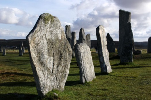
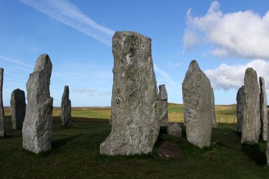
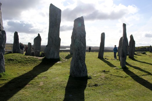
A place which, for me, has far more resonance is Callanish on the Isle of Lewis in the Outer Hebrides. Not that it is undiscovered, far from it — this 5,000 year-old stone circle has long served as a poster girl for Scottish Highlands and Islands tourism promotions — but Callanish/Calanais is at least suitably remote, close to the western shore of Lewis and the best part of an hour’s drive from Stornoway, the main town on the island.

The first thing you notice on arrival — the stones themselves are already half-familiar thanks to photographic reproduction — is the immense beauty of the landscape that surrounds the site. Less raw and perhaps a little softer than some Lewis scenery, the stones stand on a bluff above the small eponymous village that developed in their shadow. The view from the hill is a pleasing vista of lochs and inlets, with the low hills of Great Bernera rising in the distance, the outlying stones of Calanais II and III pinpointed by distant figures on their way to view them.

The stones, of course, are not deserted of people — it is a fine late September day when we visit and visitors are making the most of the clement weather. A couple of tour minibuses are parked up outside the visitor centre and the gift shop and café are both enjoying a brisk trade. Walking the short track that leads to the stones we come upon a French tour group who are engaged in photographing each other as they stroll around the monoliths. Most of the women of the group sport black midge masks that droop in front of their faces like saggy proboscises — the fine mesh protecting them from ravaging insects. The donning of masks also appears to be an unconscious act of sympathetic magic as their chosen headgear makes them look uncannily like giant flies — biped flies, that is, garbed in Gore-Tex and Barbour. Truth be told, the midges are really not all that problematic and it seems that the French fly-women are perhaps overreacting to the perceived threat. It seems a little ironic, too, that they hail from a country that banned all-enveloping face coverings like the burqa just a few years ago.
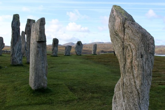
The site is relatively busy yet the proverbial camera proves to be an efficient liar. It is approaching lunchtime; the crowd around the stones has already thinned, and it does not take long to snap a number of images in which no human presence is detectable. No doubt, with sufficient Photoshop tweaking, I could possibly also adjust the contrast and saturation to simulate a sunrise rather than late morning scene. But I am happy as things are and reflect that as most of the evidence points towards Callanish being constructed as a temple orientated to moon-rise I really ought to be here at night instead.
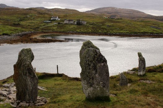
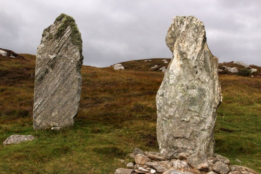
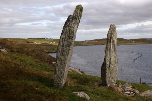
The Callanish site is well known and rightly cherished but there are other, less-heralded standing stones in the vicinity. The previous day we had come across a small group of monoliths close to the bridge that leads across to Great Bernera. These stones, fewer but similar in size and shape to those at Callanish, were of the same three-billion-year-old Lewisian gneiss, one of the oldest rocks on Earth. Known locally as Tursachan (Gaelic for ‘standing stones’), or more prosaically by archaeologists as Callanish VIII, they stood on the island of Great Bernera overlooking the bridge from the Lewis mainland. Formerly an island off an island (Lewis and Harris), which, in turn, stands off a much larger island (Scotland, England and Wales), Great Bernera has only been connected to Lewis by bridge since 1953. When first erected, the semi-circle of four large stones would have stood sentinel-like overlooking the straight between the island and Lewis; now they overlook the bridge that connects them. Unlike their better known neighbours to the east these stones are now almost forgotten. With little more than a modest signpost to point them out, they are a sidebar of prehistory, mere cartographic marginalia on the OS Explorer 458 West Lewis map.
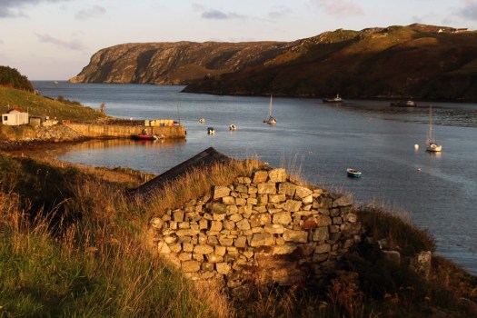 Eleven miles east of the main road, six from the nearest shop (closed on the Sabbath), two miles from the open sea as the raven flies. Glen Gravir – a slender thread of houses stretching up a glen, just four more unoccupied dwellings beyond ours before the road abruptly terminates at a fence, nothing but rough wet grazing, soggy peat and unseen lochans beyond. This was our home for the week, a holiday rental in the Park (South Lochs) district of the Isle of Lewis in the Outer Hebrides.
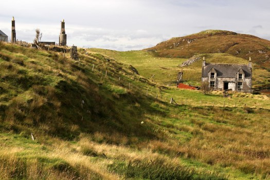
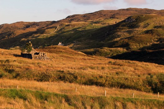 Gravir, of which Glen Gravir is but an outpost, is large enough to feature on the map, albeit in its Gaelic form, Grabhair. The village – more a loose straggle of houses and plots – possesses a school, a fire station and a church but no shop. A road from the junction with Glenside next to the church winds its way unhurriedly downhill to the sea inlet of Loch Odhairn where there is a small jetty for boats. Some of the houses are clearly empty; others occupied by crofters and incomers, their occupants largely unseen. Others are long ruined, tenanted only by raven and opportunist rowan trees, with roofs absent and little more than chimney stacks and gable walls surviving. It is only a matter of time before the stones that have been laid to construct the walls will be indistinguishable from the native gneiss that underlies the island, surfacing above the bog here and there in outcrops like human-raised cairns. Lewisian gneiss is the oldest rock in Britain. Three billion years old, two-thirds the age of our planet, it is as hard as…well, gneiss. It is the same tough unyielding rock that five thousand years ago was painstakingly worked and positioned at the Callanish stone circle close to Lewis’s western shore; the same rock used to build the island’s churches, which occupy the same sacred sites, the same fixed points of genii loci that had been identified long before Presbyterianism or any another monotheistic faith arrived in these isolated north-western isles.
 Ancient hard rock (as in metamorphic) may underlie Lewis, but religion is another bedrock of the island. Despite a respectable number of dwellings the only people we ever really see in the village are those who come in number on Sunday. The Hebridean Wee Free tradition guarantees a full car park on the Sabbath when smartly and soberly dressed folk from the wider locality congregate at Grabhair’s church, which, grave, grey and impressively large, is the only place of worship in this eastern part of the South Lochs district.
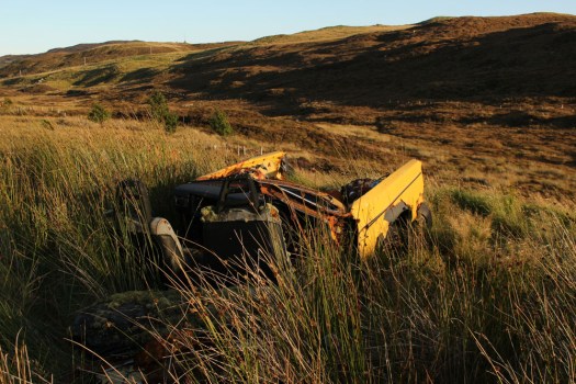
 At the bottom of the lane beneath the hillside graveyard next to the church are a couple of recycling containers for villagers to deposit their empties and waste paper. Larger items of material consumption are left to their own devices. Rain, wind and thin acidic soil are the natural agents of decay here. Beside the roadside further up from our house lie four long-abandoned vehicles in various stages of decomposition. Engines are laid bare; bodywork and chassis, buckled and distressed, rust-coated in mimicry of the colour of lichen and autumn-faded heather. Cushions of moss have colonised the seating fabric. The rubber tyres remain surprisingly intact, the longest survivor of abandonment. Sharp-edged sedges have grown around the rotting car-carcasses as if to hide them from prying eyes, preserving some modicum of dignity as the wrecks decay into the roadside bog, all glamour expunged from a lifetime spent negotiating the island’s narrow single track roads. On Lewis, vehicles die of natural causes, not geriatric intervention.
 Our cottage was rented as an island base: a place to eat, rest and sleep before setting off each morning on a long drive to visit one of Lewis’s far flung corners. Happily, it feels like a home, albeit a temporary one – a domestic cocoon of cosiness with all the modest comforts we require. Its small garden is a haven. As everywhere on the island, tangerine spikes of montbretia arch like welder’s sparks from the grass. Rabbits scamper about on the lawn, colour-flushed parties of goldfinches feed on the seed heads of knapweed outside the kitchen window. Robins, wrens and blackbirds flit around the trees and shrubs that envelop the cottage – non-native plants that have adapted to the harsh weather conditions of this north-western island, softening an outlook that on a grey, wind-blown day, with a gloomy frame of mind, might be considered bleak.
 Most days on our jaunts around the island we would see an eagle or two, golden or white-tailed, sometimes both. The majority of these sighting are in more mountainous Harris, or in that southern part of Lewis that lay close to the North Harris Hills, but on our last day on Lewis we see a white-tailed eagle fly over Orinsay, a village relatively close to where we have been staying. An hour later we spot another bird swoop along the sea loch at Cromore, a coastal village that lies a few miles to the north. It might well be the same bird. White-tailed eagles are very large and hard to miss, and their feeding range is enormous. But that is exactly how Lewis seems – enormous, almost unknowable despite its modest geographical area. A place larger than the shape on the map – a mutable landscape of rock, sky and water that does not easily lend itself to the reductionism of two-dimensional cartography.