All Fall Down

IMG_4233

Two weeks ago I read a news article about the demolition of the cooling towers at Ironbridge on the River Severn in Shropshire. Their final demise was witnessed by many who came to see the four great towers collapsing after a controlled detonation. The towers had stood for exactly half a century. Opened in 1969, the power station they belonged to had stopped generating electricity in November 2015. At one time it had provided enough electricity to power the equivalent of 750,000 homes. The space that will be made available by their removal should be sufficient for around 1,000 new homes, a park and ride, a school and leisure facilities.

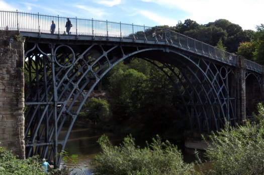
Before they came down the towers received a musical farewell when Zoë Beyers from the Royal Birmingham Conservatoire performed a solo violin piece on one of the tower platforms. The music was elegaic, an echo of the mournfulness felt by local residents and former power station workers for whom the towers had been a large part of their life. Reduced in seconds to a mere imprint of memory, the Ironbridge geography was instantly transformed for those who lived there. Particularly poignant was the fact that a little way downriver was the original Iron Bridge built in 1781, the first major bridge of its kind in the world. It was no stretch of truth to infer that it was here in Shropshire at Ironbridge and nearby Coalbrookdale that the Industrial Revolution really began.

IMG_4251

In my, admittedly limited, experience cooling towers have always stood for something. They were markers on the landscape that held deeper meaning than just supersized industrial chimneys. Travelling north up the A1(M), the cluster of eight towers at Ferrybridge in West Yorkshire always seemed to mark an arrival in the North far more effectively than any roadside sign could. Their presence spoke of a cultural transition as much as a geographical one, a shift of emphasis from pastoral to industrial. But these too were earmarked for destruction, and in 2019 five of the towers were demolished. The remaining three will be removed by summer 2021. Similarly, the pair of cooling towers that used to stand outside Sheffield at Tinsley overlooking the M1 motorway always seemed like an omphalos for Don Valley industry – a centre of gravity for the steel, coal, fire and dirt of South Yorkshire. These were of particular significance for me as they were visible from the classroom where, in a previous life, I had my first practical experience as a geography teacher. These twin towers – the ‘salt and pepper pots’ as they were sometimes known – had been redundant since the 1970s, although they managed to remain standing until 2008. Despite a scheme to convert them into giant works of public art they could not be saved. Now they are gone, redacted from the landscape, as are the steel foundries of Sheffield’s Brightside – the industrial endeavour of generations of Sheffield lives reduced to little more than memory and a plaque at a shopping mall

I do not wish to romanticise coal-fired power production – it is undeniably dirty, polluting and a significant contributor to climate change – but I cannot help but find some of the fabric of its production strangely beautiful. Smoke-belching cooling towers may well be the embodiment of Blake’s dark satanic mills but, once abandoned, the heft of their curving brickwork seems to take on an eerie beauty. Silent witnesses of the recent industrial past, their inhuman scale and brooding presence make them emblematic of the hubris that persists in these uncertain times.

IMG_4258

Another Place

IMG_5282

To reach Another Place you have to start in Liverpool. At least that is what we did, taking a Crosby-bound number 53 bus from the city’s Queen Square terminus. Leaving the Victorian magnificence of the city centre behind, the route leads through the edgelands of north Liverpool, in sight of huge abandoned red-brick warehouses that fringe the wide silver Mersey below. Away from the revitalised city centre and the heritage revamping of Albert Dock, this is a zone of substandard housing and broken dreams; a place where most of the pubs are boarded up and semi-ruined now that the dockers who once would have drank in them no longer have wage packets to fritter. The whole area seems partly abandoned to buddleia and the memory of better days although, here and there, like red-brick phoenixes, are signs of identikit housing development: new-build semi-detached homes with small gardens and big aspirations.

IMG_5244

Things seem to degenerate at the southern fringe of Bootle where the principal pub lacks not only clientele but also a roof. Narrow Victorian terrace streets slope away from the main road, their grim countenance softened by the names of flowers: Daisy Street, Woodbine Street, Harebell Street, and even a Pansy Street, which is perhaps a problematic address for a burly Scouse docker. After passing through Bootle, whose main centre of social interaction appears to be a bar located in the lower storey of a massive concrete complex that looks like it has been transported wholesale from Bratislava or New Belgrade, things start to look up, socio-economically speaking. Waterloo, where we alight next to the Merseyrail station seems altogether more prosperous, with a handful of smart cafes and a long marine parade of white-painted houses equipped with dormer windows to peer over the dunes to the beach and sea beyond.

IMG_5212

At the end of South Road, the road gives way to a track past a man-made lake behind sand dunes. Oyster catchers, gulls and ducks have taken refuge here and have arranged themselves in tightly-packed groups to brace against the bitterly cold north-westerly wind blowing across the Irish Sea. Climbing slightly to reach the dunes and a coast path, the beach and sea are revealed. As are several of the one hundred life-sized cast iron sculptures that dot the foreshore here between Waterloo and Blundellsands, and which constitute the Antony Gormley landscape installation that is Another Place (although here they are more prosaically referred to as simply ‘The Iron Men’). It is a bright, if brutally windy, afternoon and there a few people about, strolling on the beach, walking their dogs, weaving nonchalantly between the iron men that punctuate the beach like sentinels.IMG_5249

IMG_5182

The Gormley figures (modelled on the artist himself) stretch as far as the eye can see, each one staring out to sea isolated from the others: a statement on the human condition that refutes the John Donne position that ‘no man is an island’. Here, it would appear, every man is. The beauty of the figures is that, seen from afar, it is sometimes hard to distinguish those which are iron from those which are human. Covered and uncovered by each successive tide, the installation clearly points towards the relationship that exists between man and nature. Perhaps, silhouetted against the backdrop of Liverpool Dock’s cranes, it also alludes to the historical connection that links man and the seafaring trade in these parts?IMG_5177IMG_5326IMG_5260IMG_5259

IMG_5265

Crossing Morecambe Bay

IMG_0733Of all the footpaths and byways that criss-cross our ancient landscape probably the most enigmatic are those that cannot be mapped because of their very impermanence. Such routes can only be defined by their start and end points rather than the space that lies in between. These conduits of human movement are impermanent in the sense that their course is forever obliged to change with the whims of nature. What is fixed is the historical notion of the route rather than the precise territory that has been traversed. Like shipping routes that must studiously avoid rocks but which have a freer rein in safe channels, footways across tidal estuaries are fluid and everchanging. One celebrated historic route is that which crosses Morecambe Bay on the south Cumbrian coast.

IMG_0757

IMG_0859Men and women have been crossing Morecambe Bay for centuries, millennia even, but the passage has always been fraught with the danger of quicksand and fast-moving incoming tides. The tragedy that befell a group Chinese cockle diggers stranded here a decade ago is still fresh in the national psyche. Caught by the perfidious tide, abandoned by unscrupulous gangmasters, the poor migrants that perished here were caught out by both nature and the greed and indifference of their exploiters.

IMG_0791

While Morecambe Bay’s dangers are apparent enough, there is one man who, given time, can always find a way across between the south and north shores of the bay. Cedric Robinson MBE is the official ‘Queen’s Guide to the Sands of Morecambe Bay’ and receives the princely sum of £15 annually from the Crown (and a virtually rent-free cottage) for performing this duty. Formerly a fisherman and farmer, Cedric is the 25th custodian of the the title having performed the role since 1963. The first official guide was appointed by the Duchy of Lancaster back in the mid 16th century. Prior to this, it was the monks of Cartmel Priory who escorted travellers across the sands. No doubt little has changed in the way that the guides read the landscape – assessing the movement of the sands, the shift of the channels, the whereabouts of treacherous quicksand and the height of the river water. In a grudging nod to modernity, Cedric also has a tractor at his disposal.

IMG_0800

The weather forecast for our crossing from Arnside to Kents Bank was anything but auspicious, with predictions of heavy rain and the threat of the summer storms that had already tormented the south of England making an unwelcome appearance. Come the day though, there seemed to be nothing worse than light drizzle and low cloud.

IMG_0809

Something of the order of one hundred people had assembled at the jetty at Arnside for the 11am start across the bay. Cedric appeared on cue to blow his whistle and lead a colourfully (yet sensibly) clad crocodile of hikers, geocachers, dog-walkers and other outdoorsy types along the high street and past a caravan site before venturing out across the estuary. Leaving dry land behind, the group soon becomes an ambulant community, a walking-talking organism worming its way west across the sands. Crossing is exhilarating rather than a solemn trudge and the next three hours pass quickly as we walk briskly over rippled sand and wade through knee-high through channels of the River Kent, its fresh water surprisingly warm.

IMG_0797

It all seems surprisingly straightfoward, even crossing the river channels where there is a distinct undertow. Such ease of passage is thanks to Cedric who has already been out the previous day weighing up the options and marking the ever-changing route with laurel branches (‘brobs’, cut close to Cedric’s Kents Bank home at Guides Farm) that he has wedged into deep holes crow-barred into the mud. The markers are good for the next couple of days but when Cedric next takes a group out in a fortnight’s time he will need to do the pathfinding and route-marking all over again – nothing is permanent here. In Morecambe Bay the fluidity of time is all-apparent.

IMG_0760

IMG_0806Halfway across, the light rain eases and the sun appears, albeit dimly like a ghostly face through frosted glass. In the distance, a tractor and trailer driven by Cedric’s assistant can be seen on the bank of the River Kent, our first serious wade. The shoreline now seems a distant and untrustworthy illusion, the glimpses of Morecambe seen to the southeast, a phantasmagorical will-o’-the-wisp beyond a hazy threshold to another world. Once across the second of the deeper channels we wait while Cedric does some last minute route-finding, walking some distance towards the houses of Grange-over-Sands on the north shore before returning to give us the all-clear.

IMG_0851

Just before we reach the sheep-grazed marshes that fringe the shoreline, there is a moment of high drama as an area of sand the size of a car wobbles alarmingly like a jelly fish to warn of its danger: unstable quicksand with water beneath that could swallow a horse (indeed, Cedric has actually witnessed such a thing). Even the most maverick among us need no reminding to skirt this and keep moving until we are on firmer ground. A little further on and the scattered buildings of the shoreline assert themselves from behind the trees and we find ourselves climbing up to the platform of Kents Bank railway station. A southbound train is due and after bidding Cedric farewell (and purchasing a ‘Certificate of Crossing’ and a signed copy of his Time and Tide book) we climb on board for the two-stop, ten-minute journey back to Arnside. The train itself is bound for Manchester Airport, an altogether more obvious starting point for journeys to other phantasmagorical worlds that lie beyond the threshold of our imagination.

Lost Highway

Enough westering. Let’s return back across the Atlantic for this post: to Northumberland north of Hadrian’s Wall, the once lawless Reivers country where northern England meets Scotland. Not exactly east of Elveden but certainly east of Eden, the river that flows southeast from Carlisle on the Solway Firth and bisects the upland areas of the Lake District to the west and the north Pennines that lie to the east. Immediately north of here are the Cheviots, the ancient rounded hills of the Scottish Borders.

Kielder Water, a large reservoir created in the 1970s to provide a water supply for industry, has all sorts of superlatives associated with it. The reservoir itself is the largest artificial lake in the United Kingdom, while the forest that surrounds it is said to be the largest man-made area of woodland in Europe. The village that gives the reservoir its name is considered to be one of the most isolated villages in England and the area is also deemed have the clearest night skies in the UK. There is so little settlement in the vicinity that the area is relatively unsullied by light polution and, as testament to this, an astromony observatory has been constructed close to the reservoir’s northern end.

Artificial perhaps, Kileder Water is still a glorious place of long vistas and a distinct sense of isolation in winter. Alongside huge stands of Norwegian and Sitka Spruce and other would-be Christmas trees are raised banks of mature beeches and lofty stands of Scots Pines surrounding the reservoir’s cold waters. Red squirrels frolic elusively in the tops of the pines while crossbills wrench the seed from cones with their strange twisted beaks. Lying beneath the water are a scattering of buildings that once belonged to the farmland that was sacrificed to a sub-aqua future when the dam was completed. There is no sign of these now; no obvious architectural ghosts other than patterns in the water whipped up by the wind that seem to imply a regular linear structures beneath the surface – old farm walls perhaps?

What can be seen here and there though are fragments of the main road that used to run along the North Tyne Valley in the days before ‘the flood’. A modest tarmac road with a dividing white line (no cats’ eyes), this surfaces for a short stretch along part of the shore of the Bull Crag penisula at the southern end of Kielder Water. Once upon a time, this lonely road would have carried traffic north from Bellingham to Kielder village, from where it would climb higher into the Cheviots and over the Scottish border. These days, the road sees no through traffic – just a handful of walkers and mountain bikers enjoying the facilities of the forest park. The fragment that remains begins and ends in water. This palimpsest of an earlier human landscape is now, quite literally, a road to nowhere.