![Hereford_mappa_mundi_14th_cent_repro_IMG_3895[1]](https://eastofelveden.com/wp-content/uploads/2013/10/hereford_mappa_mundi_14th_cent_repro_img_38951.jpg?w=525)
This summer I visited Hereford for the first time in decades. I have long wanted to see the famous Mappa Mundi at the cathedral there and so this was an opportunity. The ancient map, along with the almost as well-known chained library, is on display in a special exhibition area beside the cloisters. With an entrance fee to pay, the map is clearly a nice little earner for Hereford Cathedral, as is the gift shop where visitors can purchase souvenir posters, books, and fridge magnets – ‘mappa money’ perhaps? It is all the more surprising then to learn that not so very long ago Hereford Cathedral was considering selling its precious artefact to raise cash and the map was saved at the eleventh hour by generous donations from the National Heritage Memorial Fund and long-time Anglophile John Paul Getty Jr.
The Mappa Mundi was made by a man called Richard de Haldingham e de Lafford from Lincolnshire, whose real name was Richard de Bello, a prebendery (senior member of clergy) of Lafford (Sleaford) in the diocese of Lincoln Cathedral. Richard was promoted to a stall in Hereford Cathedral around the end of the 13th century. The map is thought to have been drawn sometime between 1276 and 1290.
The map is certainly a wondrous thing – a single piece of vellum measuring 1.58 x 1.33 metres and tapering towards the top like an upside down shield. It depicts the world that was known in the late 13th century, a world of fact and fiction, of the familiar and fantastical, of uncanny accuracy and cartographic howlers. More than anything it is a map that superimposes the oceans and landmasses of the known world with the fantasmagorical topography of the dark medieval psyche. At the centre, of course, is Jerusalem surrounded by the continents of the Old World. Asia, the orient, lies at the top, Europe at bottom left hand corner and Africa to the right of this. Superimposed on this are drawings of famous cities and towns, Biblical events and personalities like Noah and his family at sea in the Ark, and figures from mythology like the Golden Fleece and the Cretan labyrinth. There are images of peoples of the world as well as plants, animals and disturbing weird creatures that belong to ‘Here be Dragons’ territory like Gangines, Grifones and the Sciapod, who shelters himself from the sun by the shade of a single enormous foot.
The British Isles lie at the extreme lower left hand edge of the map. England and Scotland are pinched at their join to be depicted almost as separate islands. Some of the rivers – Severn, Thames, Humber – have taken on an Amazon-like width. London and Oxford are pretty well where they should be, although Durham is clearly in the wrong place, located here south of Carlisle and west of York. There’s clearly a degree of local bias at play in the drawing of the map. Lincoln, thought to be the home town of the map’s creator, is depicted as an elaborate castle that nearly equals the Tower of London in status, while the representations of Winchester and Oxford are both rather puny in terms of their relative importance at the time. Hereford is shown as you might expect, and even nearby Clee Hill (Môr Clee) looking something like a cartoon jelly, a humble bit of topography but perhaps included as a local detail in a nod to the map’s Hereford home.
Studying the map (there’s a much clearer English equivalent on the wall opposite to facilitate this) we did what I am sure most visitors do; we looked for our own city of residence, in our case Norwich. There is no sign of it. Indeed, even the bulge of East Anglia is unrepresented as if cartographically redacted like a revisionist face on a Stalin-era photograph. The map maker, a native of Lincolnshire, would surely have known of the existence of Norwich. The city was, after all, the second largest city in England at the time. With a magnificent cathedral, a Norman castle and a large city population, the city was then a far more significant urban centre than it is today. Far more important than Hereford, Gloucestershire or even York, all of which are represented on the map.
This deliberate omission seemed a mystery until I reflected on the date of the map and what was taking place around that time. In the late 13th century several violent confrontations took place between the aggrieved citizens of Norwich and the clergy incumbent at the city’s Cathedral. As a result, Norwich has the distinction of being the only English city ever to be excommunicated following a particularly bloody riot between citizens and monks in 1274. The Etheldreda Gate to the Cathedral, which still stands today, was constructed as penance by Norwich citizens. Was it this excommunication that led Richard de Bello to ignore the city and omit it from his map? After all, the map was drawn to show the creation of God not the world of Man. Norwich, excommunicated at the time, may simply have been considered insufficiently God-fearing to be included as part of His world.
This God-less tradition may have continued to some extent. The 2011 census revealed that Norwich had the highest proportion of respondents in England and Wales saying they were of ‘no religion’ – 42.5% of the population against an average of 25.1%. There again, the city, which historically is strongly non-conformist, claims to have an above average churchgoing rate, and of the 56,268 who proclaimed no religion in the census nearly 800 were Jedi Knights.

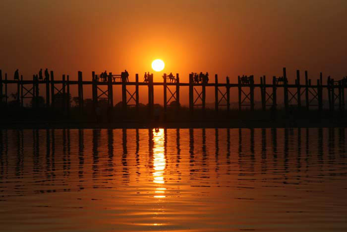
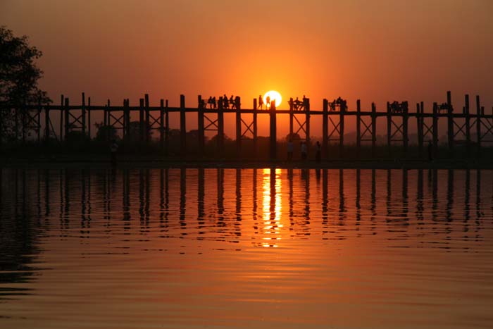
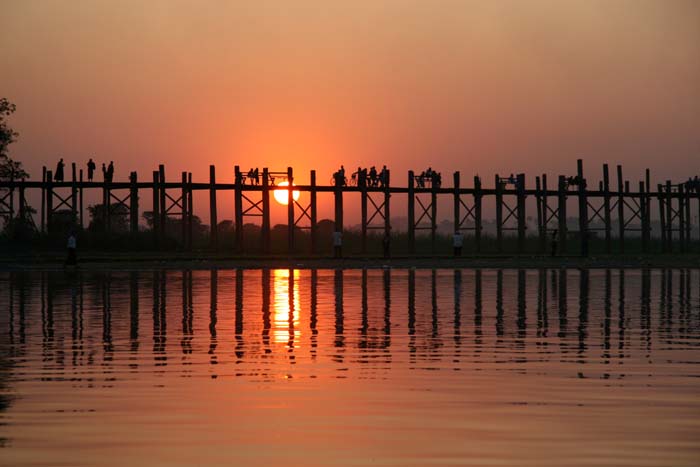
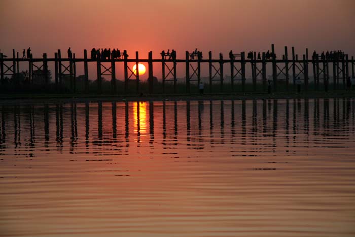
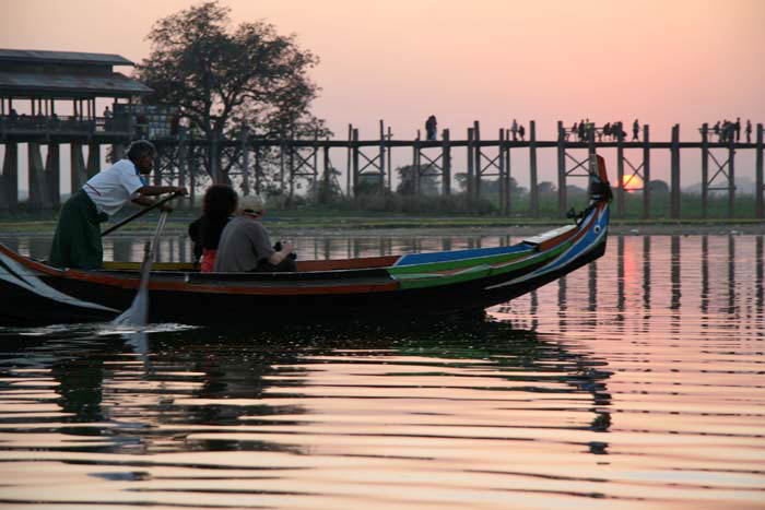
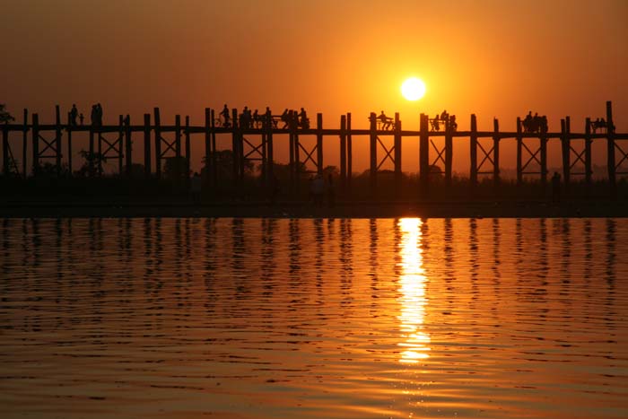 Today heralds the winter solstice in the northern hemisphere. The last couple of weeks leading up to this seasonal turning point have been characterised, in eastern England at least, by unseasonally sunny skies and sunsets so magnificent they seem to be defying the script that dictates that late December should be grim, grey and gloomy. These are short days, certainly, but days that have been beautifully illuminated by a cool, low-slung orange sun. Oddly enough, this has put me in mind of another orange sun in an altogether more exotic place.
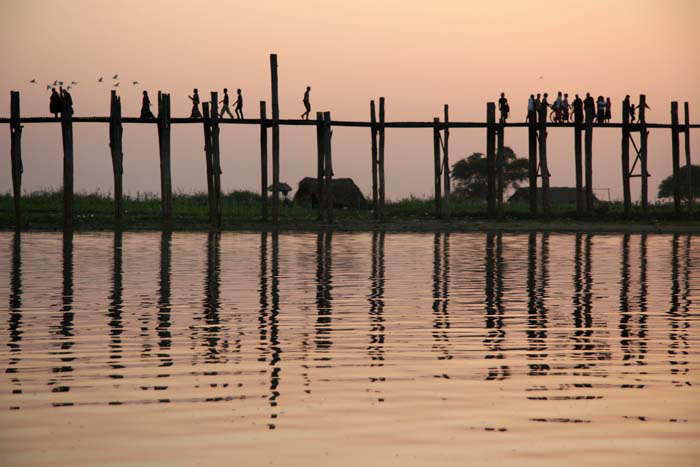


![Hereford_mappa_mundi_14th_cent_repro_IMG_3895[1]](https://eastofelveden.com/wp-content/uploads/2013/10/hereford_mappa_mundi_14th_cent_repro_img_38951.jpg)
![U237135ACME[1]](https://eastofelveden.com/wp-content/uploads/2013/09/u237135acme1.jpg)
![1849[1]](https://eastofelveden.com/wp-content/uploads/2013/08/18491.jpg)


 Three weeks ago I happened to be in London. As things turned out, on that very same day the city was somewhat preoccupied with a very high-profile event at London’s most iconic church. Given the circumstances, I felt the need to escape the gravity of St Pauls and mark my all-too-rare visit in a more personal way. So on the morning of April 17 I headed to Bunhill Fields in the Borough of Islington. Here, at a quiet Nonconformist graveyard tucked away from the thrum of city traffic, are buried some of England’s less showy heroes.
